The mildest start to December for years has seen larger sprouts than usual, early daffodils and now melting ice rinks.
Colchester Winter Wonderland and Ice Rink, which opened 25 days ago but has been unable to function on six of those days, has been forced to close down. Staff have begun dismantling the site, which included fairground attractions and festive stalls.
The company blamed “unseasonably high temperatures and strong winds throughout November and December”.
“After taking legal advice, Reflective Ice Ltd is going into liquidation and has begun the process of appointing administrators. This decision has been taken with deep regret as it will have a major impact on its staff, partners and customers,” the company said on its website.
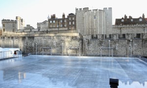
At the Tower of London, where the ice rink was closed on Wednesday because of high winds, skaters were urged to bring a change of clothing.
“Due to the the unseasonably warm weather, the ice rink may have a layer of water on it,” the venue said. We recommend you take a change of clothing with you, as if you fall you may get wet.”
Hampton Court said its rink would not open until 4pm because of the mild weather. Somerset House in central London, however, was unaffected because of a specialised cooling system and the use of purified waterthat freezes more quickly and melts more slowly.
Puddles on ice rinks are the latest manifestation of the unusually high temperatures for the time of year. The Met Office says it has been the mildest start to December since 1960 for south-east England, with an average daytime temperature of 10C in the first two weeks of the month, south-west England at 9.8C and Wales at 8.7C; and the fourth warmest for the UK as a whole, with an average temperature of 7.1C. Only 1979, 2000 and 2006 were marginally milder.
The mild weather is the result of warm Atlantic winds coming up from the Azores, thanks in part to a strong El Niño, a warm phase in the Pacific Ocean current that tracks back and forth between South America and Australia. Temperatures are forecast to dip on Christmas Day, but still remain above average.
“It is actually going to get a bit chillier and fresher and won’t be as warm as the past couple of weeks,” said a Met Office spokesperson. “There should be a chilly, bright start on Christmas Day, with temperatures of 5C to 7C in Scotland and 10C to 12C in the south.”
The day may start off sunny, but it is expected to turn wet. The Met Office says rain, persistent and heavy at times, is expected to spread north across the UK.
The north-east and north-west – including Cumbria, which has already been hit by floods – can expect most rainfall from Storm Eva. Flood warnings are in place across large swaths of the north-west, north-east and Wales and the threat is unlikely to subside in the near future.
“There is still uncertainty over where the heaviest rainfall will be in the warning area, but around 60mm to 80mm is likely to fall quite widely, with a chance of up to 150mm locally over high ground,” said the Met.
So some sun, some rain, but definitely no snow. The last time the UK experienced a white Christmas was 2010, which was also the coldest Christmas Day on record, with a minimum temperature of -18.2C recorded at Altnaharra, a remote Scottish Highland village.
For most parts of the UK, Christmas is only at the beginning of the period when it is likely to snow, according to the Met Office. Snow or sleet falls on an average of 3.9 days in December, 5.3 days in January, 5.6 days in February and 4.2 days in March.
[Source:-the gurdian]